
![]()
![]()
![]()
![]()
![]()
![]()
|
|
|
|
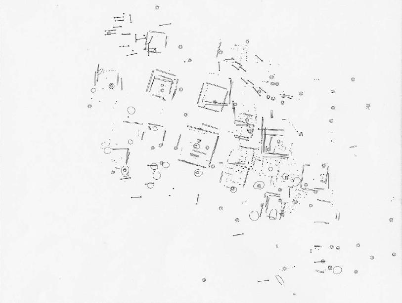
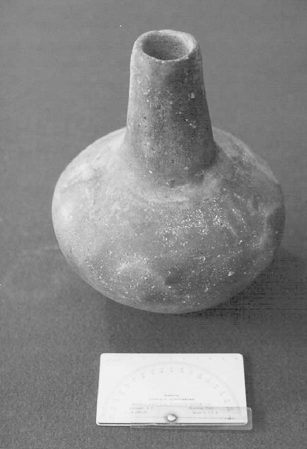
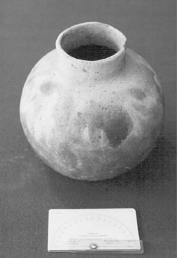
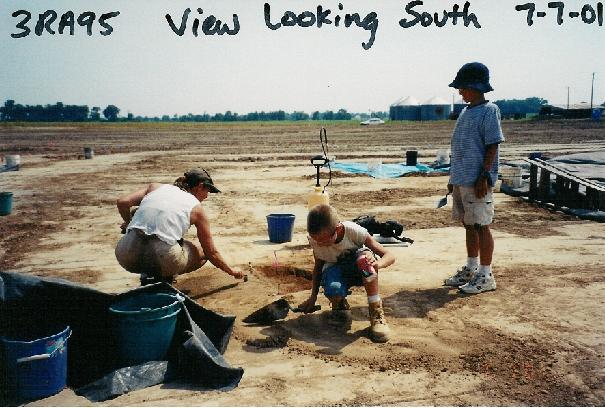
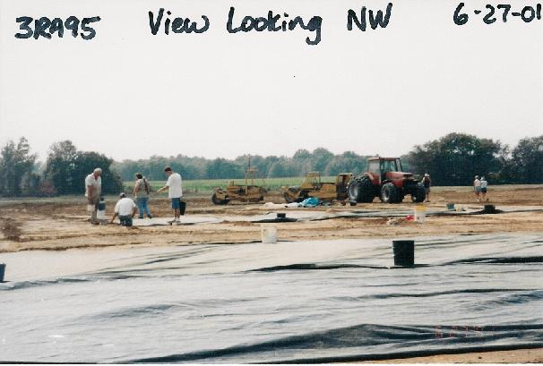
THE JARRETT SITE: A Middle Mississippian Farming Village in Northeast ArkansasBy Dr. Julie Morrow Station Archaeologist-ASUArcheological excavations in conjunction with a land-leveling project in Randolph County revealed a portion of a 700 to 900-year-old farming village that contains dozens of houses and other types of structures (Figure 1: Map). Recorded as the Jarrett site, or 3RA95, the village is located on a sand dune between the Black and Cache Rivers. The site is well known to locals who have hunted and dug for artifacts there for many years (Figure 2 and Figure 3). In the Spring of 2000, Mr. Dawson Stone who owns and farms the Jarrett site invited us to conduct an excavation so that more could be learned about the site before he leveled it. This was an historical moment in my career as ASU Station Archaeologist because, this was the first time that a landowner contacted me far in advance of proposed land-leveling. Mr. Stone even offered to strip the site of the plow layer using his dirt buggy so that we could study the portion of the site that was to be leveled. Thanks to Mr. Bill Jones, a local resident who had collected and dug artifacts from the site, I knew how important the Jarrett site was before Mr. Stone contacted me. Months earlier, he allowed me to document several complete pottery vessels from the site. When Mr. Stone scraped off the plow layer of the Jarrett site in June 2001, trash pits, house posts and trenches, hearths appeared as dark, organic-rich stains were easily visible against the light tan sand. During excavations, we learned that some of the round trash pits were dug as much as 4 feet into the clayey subsoil. Many features were mapped and excavated (Figure 4). Mr. Dawson Stone, who owns and farms the site, removed thin slices of the site off at a time throughout the summer and fall so we could learn the layout of the village and the reconstruct the history of its occupation. Each time he took another layer off, Tim of the Parkin Archeological Research Station, mapped the site using the Total Station Transit. With the help of many ASU students, Arkansas Archeological Society members, local residents from Mt. Home, Wynne, Jonesboro, Walnut Ridge, Pocahontas, and Boy Scouts from Paragould, we excavated some of the artifact –rich trash pits, as well as hearths, posts, and wall-trenches at the Jarrett site (Figure 5). The portion of the Jarrett site that was leveled consists of a cemetery area at the northwest end of the leveled area (Figure 6), scattered burials, and at least three rows of large square houses. Burials were not well-preserved but were documented. Archeological investigation focused primarily on the house structures and features. Some of the open- cornered wall trench houses range in size but on average are about 20 feet on each side.—with wide paths between the rows. During one occupation of the site the houses are oriented a few degrees east of north. A number of excavated villages of this time period (Middle Mississippian) are oriented slightly east of north. Some of the houses were rebuilt several times and some contain interior features we assume were hearths based on their rind of burned soil and their location in the center of the house. Little daub/burned clay has been recovered despite careful screening of all feature fill through ¼-inch hardware cloth and the flotation of soil samples. Sites similar to Jarrett in age and artifact content have been excavated in Poinsett County in Arkansas and along the Ozark escarpment/Little Black River in Southeast Missouri, but a large section of such a village had never before been excavated in Arkansas’ Western Lowlands. Unlike other known Middle Mississippian villages, the Jarrett site does not appear to have been fortified by a ditch and/or wooden palisade. By the late thirteenth century, many Middle Mississippian villages were fortified, probably to control traffic into and out of the village community. These gated communities may have functioned much like our gated communities today. Further investigations will determine the presence or absence of a fortification at Jarrett. The Jarrett site presents an excellent opportunity to learn how these Native farmers lived off the land here, specifics about their dwellings and the day to day activities in their households, and what the environment was like 700 to 900 or so years ago. Some of the well-preserved organic remains that have been recovered from the site include maize cob fragments, nutshells, wood charcoal, seeds, deer, bird, fish, and small mammal bones. The pottery vessel forms are dominated by plain shell-tempered jars with and without handles, water bottles, bowls, and plates. Stone tools recovered thus far include small arrow points (predominantly the Scallorn type), adzes or chisels, and chipped stone spades. Numerous chipped stone hoe flakes indicate that Mississippian farmers at the Jarrett used Mill Creek Chert from Union County in southern Illinois, to manufacture these digging tools. It is unlikely that these hoes or spades were made at the Jarrett site. Finished Mill Creek Hoes were probably obtained through the extensive trade network of the Middle Mississippian period. Although no cultural contexts have yet been dated using geochemical techniques, stone tools and ceramics from the Jarrett site suggest that it was contemporary with Cahokia in the St. Louis area, Spiro Mounds in Oklahoma, and Moundville in Alabama and other chiefdoms throughout the Eastern Woodlands. Middle Mississippian (ca. 1150-1350) trade routes were extensive and we will not be surprised to find additional exotic artifacts as the Jarrett site artifacts and flotation samples are analyzed. We are grateful to Mr. Dawson Stone and Mrs. Gayle Stone for cooperation, interest, and generosity. It is because of them that we have gathered such a wealth of information from this important Middle Mississippian period site. This case of the Jarrett site demonstrates how modern farmers in Northeastern Arkansas, without loosing time or money, can greatly help archeologists study the ancient farming cultures of Arkansas’ fertile landscape.

Figure 1 Map of Jarrett Site 3RA95 |
|
This website is maintained by Dr. Julie Morrow, jmorrow@astate.edu This page was last updated on August 10, 2005 |


